|
| The
Project |
|
| If you
want to build a sundial there are couple
of very important pieces of information
required. One of these is that you have
to know where you are. Unfortunately,
"Pinawa" just doesn't happen to
be close enough. You must establish the
latitude and longitude of the location of
the sundial as accurately as possible.
The second piece of information required
is: "Which way is north?". Here
again, pulling out the compass won't give
you the entire answer. A compass will
tell the way to magnetic north but you
need to know the direction to true north. Fortunately,
we have a volunteer who could help get
all the answers we need: Barrie
Burnett.
Barrie's hobby is surveying and he he
spends a great deal of time doing what he
loves to do. Barrie has been surveying
the town for over 20 years. To do this he
has invested a lot in purchasing
equipment for his hobby and because
Barrie normally surveys alone, he has
come up with some ingenious devices to
help him in the field.
|
|
|
 |
This is
Barrie with some of the equipment we used
during the project. THANKS
BARRIE!
|
|
| With
the aid of the many control points Barrie
has established throughout town, he was
able to determine the latitude and
longitude of the sundial's position. This
information is required to perform the
calculations for the hour angles of the
sundial. The latitude also determines the
slope of the gnomon. So,
where are we? This is the location of the
sundial.
Latitude:
50°08'48" North
Longitude: 95°52'31" West
North
American Datum — 1983
Barrie
also established the direction of true
north. We laid out a north-south line on
the parking lot adjacent to the sundial
with the use of surveying instruments and
then confirmed it using a cool tool
Barrie made.
|
|
 |
 |
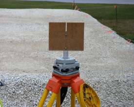
| The
photos above show how we were able to
confirm the north- south line. Barrie's
cool tool was set on a very tall tripod
directly over the control point at the
south end of the lot. We used the clock
display on an HP41CX programmable
calculator. The clock was synchronized
with an NRC time signal over the
telephone. This signal is provided at 10
second intervals. We determined the
precise clock time for solar noon on the
day of the test. We then positioned a
piece of paper on the ground at the point
where the tool would cast a beam of light
the width of the slot. Positioning
ourselves, we waited for high noon. OOPS!
Cloud at 12 o'clock.
The
next day we set up we were successful. At
precisely noon Barrie marked one edge of
the light beam and I marked the other.
It's surprising how quickly the light
beam was moving. After bisecting the
distance between the two marks, Barrie
found that the surveyed line matched
perfectly with the north-south line
determined with the cool tool. Go figure!
Barrie's
surveying skills did not end here. His
involvement was critical to the success
of this project. He spent numerous hours
at the site surveying as well as many
hours in his cartography studio preparing
the data necessary for the field work.
|
|
|
 |
 |
| Rain
or shine, you could always depend on Barrie! |
|


